5 minutes ago loud explosion and shook the house. It made my decision to get up and get dressed.
Can’t see any thing but grey ashy looking sky. Don’t want to stay out for too long. Still trying to find out what the boom was.
5 minutes ago loud explosion and shook the house. It made my decision to get up and get dressed.
Can’t see any thing but grey ashy looking sky. Don’t want to stay out for too long. Still trying to find out what the boom was.

This is an Eruption update for Wednesday, November 30th at 8 in the morning.
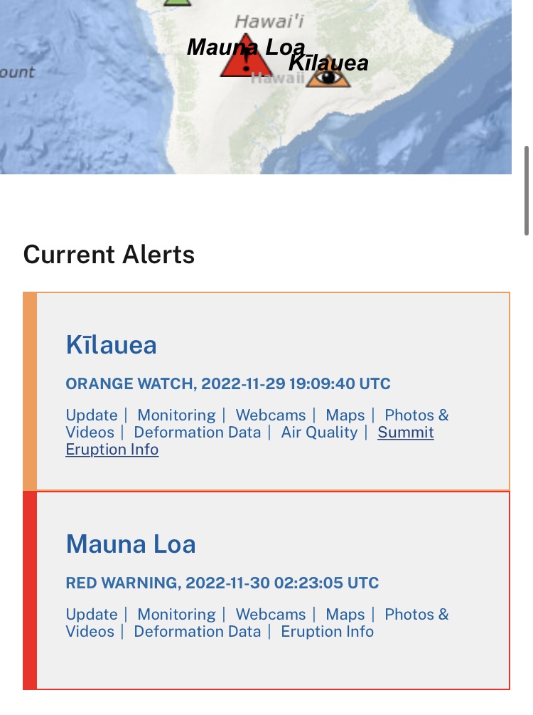
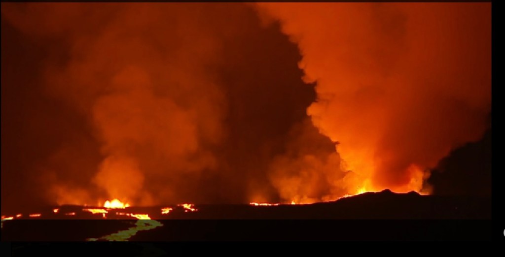
Hawaiian Volcano Observatory reports the leading edge of the lava flow on Mauna Loa’s northeast flank is above 7,000 foot elevation and more than 3 miles from Daniel K. Inouye Highway.
Daniel K. Inouye Highway is open in both directions.
Vehicle parking along Daniel K. Inouye Highway is unsafe and prohibited.
Hawaii Police Department reports that motorists that park along Daniel K. Inouye Highway between the 16 and 31 Mile Markers will be subject to traffic citation and vehicles will be towed.
You will be updated of any changes that affect your safety.
This is your Hawaii County Civil Defense Agency.Confirm Receipt© 2022 Everbridge, Inc.

This is an Eruption update for Tuesday, November 29th at 10 in the morning.
USGS – Hawaiian Volcano Observatory reports the leading edge of the lava flow on Mauna Loa’s northeast flank remains at a high elevation of over 9,000 feet and more than 5 miles from Saddle Road.
As stated, the northeast flank of Mauna Loa is not populated and lava continues to not pose a threat to any communities or infrastructure, at this time.
Due to no threat to communities at this time, shelters that were opened yesterday at Old Kona Airport in Kailua-Kona and Ka`u Gymnasium in Pahala as a precaution, will be closed at noon today.
For those traveling Saddle Road /Daniel K. Inouye Highway, parking along the highway is unsafe and prohibited. Hawaii Police Department report that vehicles that park along Saddle Road /Daniel K. Inouye Highway between the 16 and 31 Mile Markers will be subject to citation and will be towed.
You will be informed of any changes that affect your safety.
This is your Hawaii County Civil Defense Agency.Confirm Receipt© 2022 Everbridge, Inc.

Measure you doorways and windows that you want to leave open to get fresh air.

Go to your hardware store and pick up HVAC Filters. They have various sizes. I used 20 x 25 on the doors and 16x 20 for the windows. You need 2 pieces of wood 1“x 2” x 8 feet per door. Windows I just used the duct tape

Tools you’ll need. Duct tape, scissors, utility knife, tape measure, filters.
Doorway: Cut your wood to the correct size. Lay the wood down and stick the filters in between the 2 pieces of wood. Measure both sides so it is even or your pañal will be crooked. Tape each side length wise first and flip it over and tape. Then tape each individual panel and go around the wood.
You won’t need wood for the windows. Just tape the panels together after measuring.


This is an Eruption message for Monday, November 28th at 12:30 AM.

USGS – Hawaiian Volcano Observatory reports an eruption at the summit of Mauna Loa is occurring.
USGS – Hawaiian Volcano Observatory and Civil Defense are activated and monitoring the situation.
The eruption is confined to the summit of Mauna Loa and there are no lava flow threats to communities and there is no evacuation requested at this time.
You will be informed of any changes that affect your safety.
This is your Hawaii County Civil Defense Agency.Confirm Receipt© 2022 Everbridge, Inc.


By Chad Rhodes 6/3/2018 3:30 pm
I am no longer getting my drinking water from Pahoa side. Now going Keaau side. If the methane gas is present who’s to say it has not already penetrated the water table in Pahoa. Where is that water table in Pahoa. Feast your pretty eyes on this. This is why I have brought up these issues. I have not heard any one mention the water source for the Puna District.
General
The Kilauea Aquifer Sector Area (ASEA) includes the Pahoa [80801], Kalapana [80802], Hilina[80803], and Keaiwa [80804] Aquifer System Areas (ASYA). It captures most of the Puna District and the southeastern portion of the Kau District, and extends along most of the island’s southeastern coastline as far south as Kuhua Bay outside Punaluu. The sector area includes most of the Kilauea Crater and Hawaii Volcanoes National Park.
Economy
Agriculture is the primary economic function in the Puna District. Vegetables / Papayas in the Kapoho area, flowers in the Pahoa and Kapoho areas, and bananas are the principal products. Truck farming in the Volcano area is also significant. The majority of the State’s papayas and bananas are grown in Puna. Several Marijuana growers due to the sunny, hot, humid days.
The Puna Geothermal Venture (PGV) plant located outside of Kapoho generates 30-MW of electricity using three geothermal wells. Plans were already under way to expand the facility to double its output, but Pele put a stop to that we hope.. PGV had employed 30 people.
Population
Nearly all of the population contributing to the demands from the Kilauea ASEA is within the Puna District. The rate of growth of Puna’s population has slowed in the past few years., but still ranks as the island’s highest. The growth can be attributed to the affordability of residences outside of Hilo and the job opportunities in Hilo. Puna’s status as a “bedroom community” for Hilo is evident from much slower growth in employment, and the worsening traffic on its roads leading into Hilo.
Ok, you have a little better understanding why I have concern. Lager Population, PGV Leaking into Aquifer, Fertilizers used by farmers, cars and other contaminants. Now look at the map and tell me that the Aquifer could not be at risk.


![]()
KILAUEA VOLCANO (VNUM #332010)
19°25’16” N 155°17’13” W, Summit Elevation 4091 ft (1247 m)
Current Volcano Alert Level: WARNING
Current Aviation Color Code: ORANGE
Lower East Rift Zone Eruption
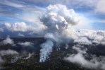
The intermittent eruption of lava in Leilani Estates in the lower East Rift Zone of Kīlauea Volcano continues. Visible activity this early afternoon was again focused on the northeast portion of the fissure area. Fissure 15 broke ground across Poihiki Road, generating a pahoehoe flow about 20 m (66 ft) long. During an overflight of the area about 3 p.m. HST, geologists observed a new steaming area uprift (west) of Highway 130. During a second overflight at 4:30 p.m., the area was still steaming.
Rates of motion increased late this morning on a GPS station 1.5 km (1 mile) southeast of Nanawale Estates. The direction of motion is consistent with renewed movement of magma in the downrift direction (to the northeast).
Rates of seismicity changed little throughout the day; located earthquakes were mostly uprift (west) of Highway 130. Gas emissions remain elevated in the vicinity of fissures.
Residents should remain informed and heed Hawaii County Civil Defense closures, warnings, and messages (http://www.hawaiicounty.gov/active-alerts).
For maps showing the locations of eruption features, please see https://volcanoes.usgs.gov/volcanoes/kilauea/multimedia_maps.html
For information on volcanic air pollution, please see: http://www.ivhhn.org/vog/
Kīlauea Volcano Summit
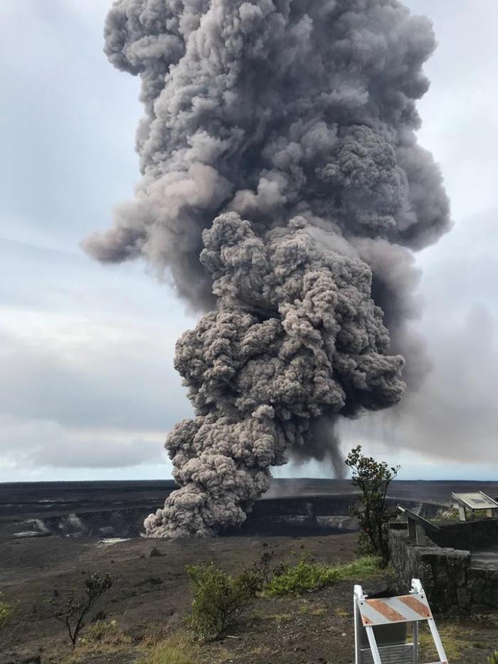
Tiltmeters at the summit of Kīlauea Volcano continue to record the deflationary trend of the past week and the lava lake level continues to drop. At about 8:32 a.m. HST, a large rockfall from the steep crater walls into the retreating lake triggered an explosion that generated an ash column above the crater; the ash was blown toward the south-southwest. Rockfalls and explosions that produce ash columns are expected to continue.
A 3D model of the Overlook crater was created from thermal images collected during an early afternoon helicopter overflight on May 8. Based on the 3D model, the lake level was about 295 m (970 feet) below the floor of Halema’uma’u Crater.
Earthquake activity in the summit remains elevated. Many of these earthquakes are related to the ongoing subsidence of the summit area and earthquakes beneath the south flank of the volcano.
MORE INFORMATION
Activity Summary also available by phone: (808) 967-8862
Subscribe to these messages: https://volcanoes.usgs.gov/vns2/
Webcam images: https://volcanoes.usgs.gov/volcanoes/kilauea/multimedia_webcams.html
Photos/Video: https://volcanoes.usgs.gov/volcanoes/kilauea/multimedia_chronology.html
Lava Flow Maps: https://volcanoes.usgs.gov/volcanoes/kilauea/multimedia_maps.html
Definitions of terms used in update: https://volcanoes.usgs.gov/volcanoes/kilauea/extra/definitions.pdf
Overview of Kīlauea summit (Halemaʻumaʻu) and East Rift Zone (Puʻu ʻŌʻō ) eruptions:
Click to access background.pdf
Summary of volcanic hazards from Kīlauea eruptions:
Recent Earthquakes in Hawai’i (map and list):
https://volcanoes.usgs.gov/hvo/earthquakes/
Explanation of Volcano Alert Levels and Aviation Color Codes:
https://volcanoes.usgs.gov/activity/alertsystem/index.php
https://pubs.usgs.gov/fs/2006/3139/
CONTACT INFORMATION:
askHVO@usgs.gov
The Hawaiian Volcano Observatory is one of five volcano observatories within the U.S. Geological Survey and is responsible for monitoring volcanoes and earthquakes in Hawai`i.

![]()
Rockfall generates a short-lived explosion at Halema‘uma‘u crater, at 8:27 a.m. HST, May 9.
An ash column rises from the Overlook crater at the summit of Kīlauea Volcano today. The USGS-Hawaiian Volcano Observatory’s interpretation is that the explosion was triggered by a rockfall from the steep walls of Overlook crater.
The summit lava lake level has dropped about 220 m (722 ft) below the crater rim from April 30-May 7. The water table is about 460m (1970 ft) below the caldera floor. This explosion was due to a rockfall and not the interaction of magma with the water table.
This photograph was taken at 8:29 a.m. HST on May 9, from the Jaggar Museum overlook. The explosion was short-lived. Geologists examining the ash deposits on the rim of Halema‘uma‘u crater found fresh lava fragments hurled from the lava lake. This explosion was not caused by the interaction of the lava lake with the water table. When the ash cleared from the crater about an hour after the explosion, geologists were able to observe the lava lake surface, which is still above the water table.
#usgs #hvo #hawaiianvolcanoobservatory #kilauea #volcano #PuuOo #KilaueaErupts #LeilaniEstatesEruption #leilaniestates

Volcano: Kilauea (VNUM #332010)
Current Volcano Alert Level: WARNING
Current Aviation Color Code: ORANGE
Issued: Wednesday, May 9, 2018, 8:02 AM HST
Source: Hawaiian Volcano Observatory
Notice Number:
Location: N 19 deg 25 min W 155 deg 17 min
Elevation: 4091 ft (1247 m)
Area: Hawaii
Volcanic Activity Summary: The steady lowering of the lava lake in “Overlook crater” within Halemaʻumaʻu at the summit of Kīlauea Volcano has raised the potential for explosive eruptions in the coming weeks. If the lava column drops to the level of groundwater beneath Kīlauea Caldera, influx of water into the conduit could cause steam-driven explosions. Debris expelled during such explosions could impact the area surrounding Halemaʻumaʻu and the Kīlauea summit. At this time, we cannot say with certainty that explosive activity will occur, how large the explosions could be, or how long such explosive activity could continue.
Residents of the Kīlauea summit area should learn about the hazards of ashfall, stay informed of the status of the volcano and area closures, and review family and business emergency plans.
Resource on volcanic ash hazards: https://volcanoes.usgs.gov/volcanic_ash/
![]()
Remarks: HAZARDS
Primary hazards of concern should this activity occur are ballistic projectiles and ashfall.
BALLISTIC PROJECTILES
During steam-driven explosions, ballistic blocks up to 2 m (yards) across could be thrown in all directions to a distance of 1 km (0.6 miles) or more. These blocks could weigh a few kilograms (pounds) to several tons.
Smaller (pebble-size) rocks could be sent several kilometers (miles) from Halemaʻumaʻu, mostly in a downwind direction.
ASHFALL
Presently, during the drawdown of the lava column, rockfalls from the steep enclosing walls of the Overlook crater vent impact the lake and produce small ash clouds. These clouds are very dilute and result in dustings of ash (particles smaller than 2 mm) downwind.
Should steam-driven explosions begin, ash clouds will rise to greater elevations above ground. Minor ashfall could occur over much wider areas, even up to several tens of miles from Halemaʻumaʻu. In 1924, ash may have reached as high as 20,000 feet above sea level. Small amounts of fine ash from these explosions fell over a wide area as far north as North Hilo (Hakalau), in lower Puna, and as far south as Waiohinu.
GAS
Gas emitted during steam-drive explosions will be mainly steam, but will include some sulfur dioxide (SO2) as well. Currently, SO2 emissions remain elevated.
WARNING TIME
Steam-driven explosions at volcanoes typically provide very little warning. Once the lava level reaches the groundwater elevation, onset of continuous ashy plumes or a sequence of violent steam-driven explosions may be the first sign that activity of concern has commenced.
BACKGROUND
Kīlauea’s lava lake began to drop on May 2, 2018. From its peak on May 2 to the most recent measurement at 9 pm on May 6, the lava lake surface dropped a total of more than 200 m (656 ft). The subsidence was at a relatively constant rate of about 2 meters (yards) per hour.
Measurements of subsidence have not been possible since May 6 because of thick fume and the increasing depth to the lava surface. However, thermal images indicate continued lowering of the lake surface since that time, consistent with deflationary tilt recorded at Kīlauea’s summit. Therefore, we infer that the lake surface continues to drop at roughly the same rate. So, while HVO cannot report exact depths of the receding lava lake, we can monitor the overall trend.
USGS and HVO scientists are monitoring changes at the summit 24/7 and watching for signs that hazardous conditions have increased, or may increase. HVO is working closely with Hawai’i Volcanoes National Park and Hawai’i County Civil Defense to respond to this situation.
FOR MORE INFORMATION
Updates on activity will be posted on the HVO website at https://volcanoes.usgs.gov/volcanoes/kilauea/status.html
You can receive these updates by email through a free subscription service: https://volcanoes.usgs.gov/vns2/
Hawai’i County Civil Defense will issue its own hazard notices should that become necessary: http://www.hawaiicounty.gov/active-alerts/
Hawai’i Volcanoes National Park status is posted on their web page:
https://www.nps.gov/havo/index.htm
Resources on volcanic ash can be found at:
https://volcanoes.usgs.gov/volcanic_ash/
Contacts: askHVO@usgs.gov
Next Notice: Daily updates on all volcanic activity at Kīlauea are issued each morning and posted on out website: https://volcanoes.usgs.gov/volcanoes/kilauea/status.html
You can sign up to receive these messages automatically by visiting https://volcanoes.usgs.gov/vns2/
The Hawaiian Volcano Observatory is one of five volcano observatories within the U.S. Geological Survey and is responsible for monitoring volcanoes and earthquakes in Hawai`i.

by Chad Rhodes May 8, 2018 10:34 AM


The big question the last few days has been “Whats the VOG going to do to us humans and our pets?”
Noxious sulfur dioxide gas and other pollutants emitted from Kilauea Volcano on the Island of Hawai`i react with oxygen and atmospheric moisture to produce volcanic smog (vog) and acid rain. Vog poses a health hazard by aggravating preexisting respiratory ailments, and acid rain damages crops and can leach lead into household water supplies. The U.S. Geological Survey’s Hawaiian Volcano Observatory is closely monitoring gas emissions from Kilauea and working with health professionals and local officials to better understand volcanic air pollution and to enhance public awareness of this hazard.
Leilani Estates and Lanipuna Gardens are both consumed by noxious gases and are not safe for humans or pets to live in.
Thick, acrid haze has started to cover all of the East side of the island. A resident from Hawaiian Paradise Park, approximately 15 miles from the eruption in Leilani Estates said “for the last 2 days we have had vog and ash. As you can see my fan is covered in what I am assuming is ash from Leilani Estates or Kilauea”.


We were warned early and told that outdoor activities in parks/ beaches might be canceled in affected areas and that schools might need to keep children indoors. People were also warned to be aware of respiratory problems, as these conditions could deteriorate more rapidly in areas of heavier haze. Keep your pets indoors if possible. This choking haze was not caused by a forest fire or industrial pollution but by light winds blowing gas emissions from Leilani Estates and/or Kilauea Volcano into the area.
SO2 is a poisonous gas that irritates skin and the tissues and mucous membranes of the eyes, nose, and throat. During even moderate physical activity, SO2 penetrates deeply into the airway and can produce respiratory distress in some individuals.
Many residents and visitors on the Island of Hawai`i report physical complaints associated with vog exposure. These complaints include headaches, breathing difficulties, increased susceptibility to respiratory ailments, watery eyes, sore throat, flu-like symptoms, and a general lack of energy. In contrast to SO2 gas concentration near Kilauea, the amount of aerosol particles in Hawaii’s air does not routinely exceed Federal standards, but the unique combination of acidic particles, trace amounts of toxic metals, and SO2 gas in vog may account for the wide variety of physical symptoms reported.
For More Information on Vog please see USGS


