MOST IMPORTANTLY: KEEP YOUR FACE, HANDS and EYES COVERED.
Always wash your hands and change clothes as soon as you get home.
Try and keep the contamination to one area.
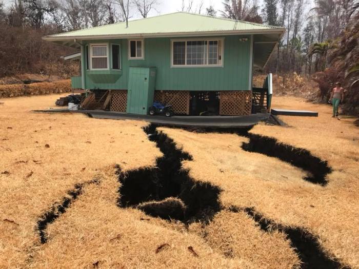
If you are one of the few that come home to one of the burnt out neighborhoods make sure you exercise caution while out in the elements.
That means anytime you are outside make sure you follow these simple emergency instructions to cleansing your body.
You do not want to inhale any of the elements that is on fire or has been burnt out.
Respiratory infections and many other illness can be blamed on large burn out fires as these.
Think about how many toxic products that are in our homes. Make sure if moving one of these items you are prepared with emergency protection gear.
Refrigerator, microwaves, cars, carpet, wood flooring that has been treated and those are just a few things that every home may have.
Your home and residing in the neighborhood: Set up an area that you can seal off. If you have a separate hall way that you can close off with plastic or a separate entry, perhaps through the side garage door(not a big one)with door to house. Handy to change contaminated clothes.
Even though your area may not have flames crawling up your street or that you can actually see, remember embers and ash can float through the air. It will glide until it gets caught on a branch or something to cling onto.
Make sure you bath each night before you go to bed.
Open your pores with warm water and use a good scrubby or washcloth with loads of soap. Soap up really good. Use cold water after to wash the soap off and close your pores.
Keep all of your smoke clothes in a plastic bag in your sealed area until you wash them. You don’t want to spread the smell or contaminate any other area.
If you are in close vicinity of the devastated areas: Do Not run any fans or air conditioning that has a connetion to outdoors. Close all doors, windows and vents. Close blinds and curtains to keep sun out and temperatures down in the house.
We are sending out a “HOLLA” for you to share Please.
We have several Lost and Found pets that need their owners. They were scared and hungry, but now are safe. All organizations are looking for people to Sharing posts with friends and family is #1, volunteering time to help with the pets and offer space in their homes for these pets. Short Stay and Long Stay, permanent and temporary.
The Hawaiʻi Lava Flow Animal Rescue Network (HLFARN) was created to serve as an informational hub for those needing assistance with pets and animals on farms during the 2018 eruption of Kilauea on the Big Island of Hawaiʻi. But it has become so much more than that. HLFARN has blossomed from a group of strangers into an Ohana; a family of people whose love for animals has taken them into the path of an erupting volcano to rescue pets and farm animals that have been left behind.
The STRANGEST SMELL came over Hawaiian Paradise Park and Orchidland at 9:30 am this morning as these wispy strange looking clouds came over. I called my friend Lisa ask her if she smells a strange odor. Yes i smell that also.Then about 10:00 am military plane shows up going through all these clouds back and forth. I call my friend Lisa to tell her to look she is up mountain from me. she says yes i see. My face and lips were stinging when I came back in. The plane kept coming again and again. Don’t know what it was, but it made me cough and my skin is itchy too.
They keep down Playing the PGV (Puna Geothermal Venture Plant) facts. Those facts could kill the whole community in Puna district and then some. They really have no idea. It depends on a lot of factors: wind speed, cloud formation, height and weight, time of day, Day Or Night . So many factors and a lot of people are acting like “it’s all good, I got this”… “Do you really got this”.?
Most stores in Pahoa, Hawaii have sold out of protection masks.
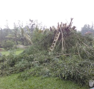
You really need to keep a gas mask on hand if you are going to live on a volcano or even near one. It was terrible working in the Vog and rain. But when you have work that needs to get done. You do it. Trimming for hurricane season. We are ready for what ever comes this way.
Yes, no blue skies… Sad only grey 😦
So this is the one I have in my survival kit. Its simple and the filters keep most gases from entering.
HAWAIIAN VOLCANO OBSERVATORY STATUS REPORT U.S. Geological Survey Wednesday, May 9, 2018, 4:55 PM HST (Thursday, May 10, 2018, 02:55 UTC)
KILAUEA VOLCANO (VNUM #332010)
19°25’16” N 155°17’13” W, Summit Elevation 4091 ft (1247 m)
Current Volcano Alert Level: WARNING
Current Aviation Color Code: ORANGE
Lower East Rift Zone Eruption
The intermittent eruption of lava in Leilani Estates in the lower East Rift Zone of Kīlauea Volcano continues. Visible activity this early afternoon was again focused on the northeast portion of the fissure area. Fissure 15 broke ground across Poihiki Road, generating a pahoehoe flow about 20 m (66 ft) long. During an overflight of the area about 3 p.m. HST, geologists observed a new steaming area uprift (west) of Highway 130. During a second overflight at 4:30 p.m., the area was still steaming.
Rates of motion increased late this morning on a GPS station 1.5 km (1 mile) southeast of Nanawale Estates. The direction of motion is consistent with renewed movement of magma in the downrift direction (to the northeast).
Rates of seismicity changed little throughout the day; located earthquakes were mostly uprift (west) of Highway 130. Gas emissions remain elevated in the vicinity of fissures.
Kīlauea Volcano Summit
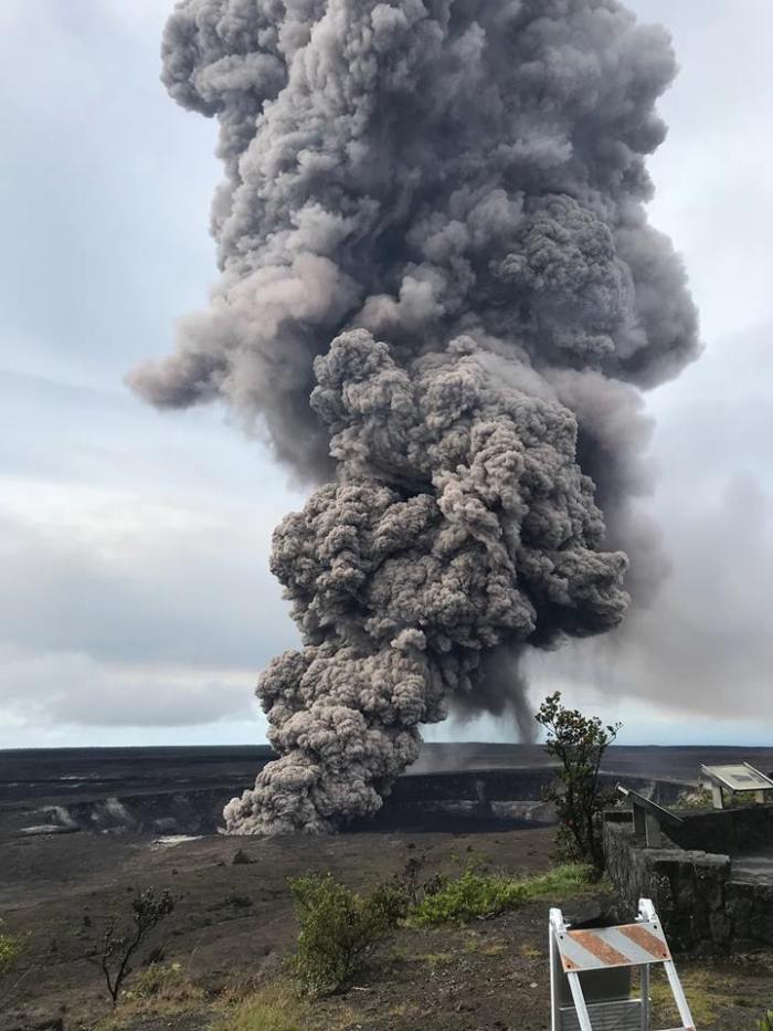
Tiltmeters at the summit of Kīlauea Volcano continue to record the deflationary trend of the past week and the lava lake level continues to drop. At about 8:32 a.m. HST, a large rockfall from the steep crater walls into the retreating lake triggered an explosion that generated an ash column above the crater; the ash was blown toward the south-southwest. Rockfalls and explosions that produce ash columns are expected to continue.
A 3D model of the Overlook crater was created from thermal images collected during an early afternoon helicopter overflight on May 8. Based on the 3D model, the lake level was about 295 m (970 feet) below the floor of Halema’uma’u Crater.
Earthquake activity in the summit remains elevated. Many of these earthquakes are related to the ongoing subsidence of the summit area and earthquakes beneath the south flank of the volcano.
MORE INFORMATION
Activity Summary also available by phone: (808) 967-8862
The Hawaiian Volcano Observatory is one of five volcano observatories within the U.S. Geological Survey and is responsible for monitoring volcanoes and earthquakes in Hawai`i.
Rockfall generates a short-lived explosion at Halema‘uma‘u crater, at 8:27 a.m. HST, May 9.
An ash column rises from the Overlook crater at the summit of Kīlauea Volcano today. The USGS-Hawaiian Volcano Observatory’s interpretation is that the explosion was triggered by a rockfall from the steep walls of Overlook crater.
The summit lava lake level has dropped about 220 m (722 ft) below the crater rim from April 30-May 7. The water table is about 460m (1970 ft) below the caldera floor. This explosion was due to a rockfall and not the interaction of magma with the water table.
This photograph was taken at 8:29 a.m. HST on May 9, from the Jaggar Museum overlook. The explosion was short-lived. Geologists examining the ash deposits on the rim of Halema‘uma‘u crater found fresh lava fragments hurled from the lava lake. This explosion was not caused by the interaction of the lava lake with the water table. When the ash cleared from the crater about an hour after the explosion, geologists were able to observe the lava lake surface, which is still above the water table.
Issued: Wednesday, May 9, 2018, 8:02 AM HST Source: Hawaiian Volcano Observatory Notice Number: Location: N 19 deg 25 min W 155 deg 17 min Elevation: 4091 ft (1247 m) Area: Hawaii
Volcanic Activity Summary: The steady lowering of the lava lake in “Overlook crater” within Halemaʻumaʻu at the summit of Kīlauea Volcano has raised the potential for explosive eruptions in the coming weeks. If the lava column drops to the level of groundwater beneath Kīlauea Caldera, influx of water into the conduit could cause steam-driven explosions. Debris expelled during such explosions could impact the area surrounding Halemaʻumaʻu and the Kīlauea summit. At this time, we cannot say with certainty that explosive activity will occur, how large the explosions could be, or how long such explosive activity could continue.
Residents of the Kīlauea summit area should learn about the hazards of ashfall, stay informed of the status of the volcano and area closures, and review family and business emergency plans.
Primary hazards of concern should this activity occur are ballistic projectiles and ashfall.
BALLISTIC PROJECTILES
During steam-driven explosions, ballistic blocks up to 2 m (yards) across could be thrown in all directions to a distance of 1 km (0.6 miles) or more. These blocks could weigh a few kilograms (pounds) to several tons.
Smaller (pebble-size) rocks could be sent several kilometers (miles) from Halemaʻumaʻu, mostly in a downwind direction.
ASHFALL
Presently, during the drawdown of the lava column, rockfalls from the steep enclosing walls of the Overlook crater vent impact the lake and produce small ash clouds. These clouds are very dilute and result in dustings of ash (particles smaller than 2 mm) downwind.
Should steam-driven explosions begin, ash clouds will rise to greater elevations above ground. Minor ashfall could occur over much wider areas, even up to several tens of miles from Halemaʻumaʻu. In 1924, ash may have reached as high as 20,000 feet above sea level. Small amounts of fine ash from these explosions fell over a wide area as far north as North Hilo (Hakalau), in lower Puna, and as far south as Waiohinu.
GAS
Gas emitted during steam-drive explosions will be mainly steam, but will include some sulfur dioxide (SO2) as well. Currently, SO2 emissions remain elevated.
WARNING TIME
Steam-driven explosions at volcanoes typically provide very little warning. Once the lava level reaches the groundwater elevation, onset of continuous ashy plumes or a sequence of violent steam-driven explosions may be the first sign that activity of concern has commenced.
BACKGROUND
Kīlauea’s lava lake began to drop on May 2, 2018. From its peak on May 2 to the most recent measurement at 9 pm on May 6, the lava lake surface dropped a total of more than 200 m (656 ft). The subsidence was at a relatively constant rate of about 2 meters (yards) per hour.
Measurements of subsidence have not been possible since May 6 because of thick fume and the increasing depth to the lava surface. However, thermal images indicate continued lowering of the lake surface since that time, consistent with deflationary tilt recorded at Kīlauea’s summit. Therefore, we infer that the lake surface continues to drop at roughly the same rate. So, while HVO cannot report exact depths of the receding lava lake, we can monitor the overall trend.
USGS and HVO scientists are monitoring changes at the summit 24/7 and watching for signs that hazardous conditions have increased, or may increase. HVO is working closely with Hawai’i Volcanoes National Park and Hawai’i County Civil Defense to respond to this situation.
The Hawaiian Volcano Observatory is one of five volcano observatories within the U.S. Geological Survey and is responsible for monitoring volcanoes and earthquakes in Hawai`i.